App for iPhone
I’m Safe: Air Raid Shelters
Nearest shelter, even offline
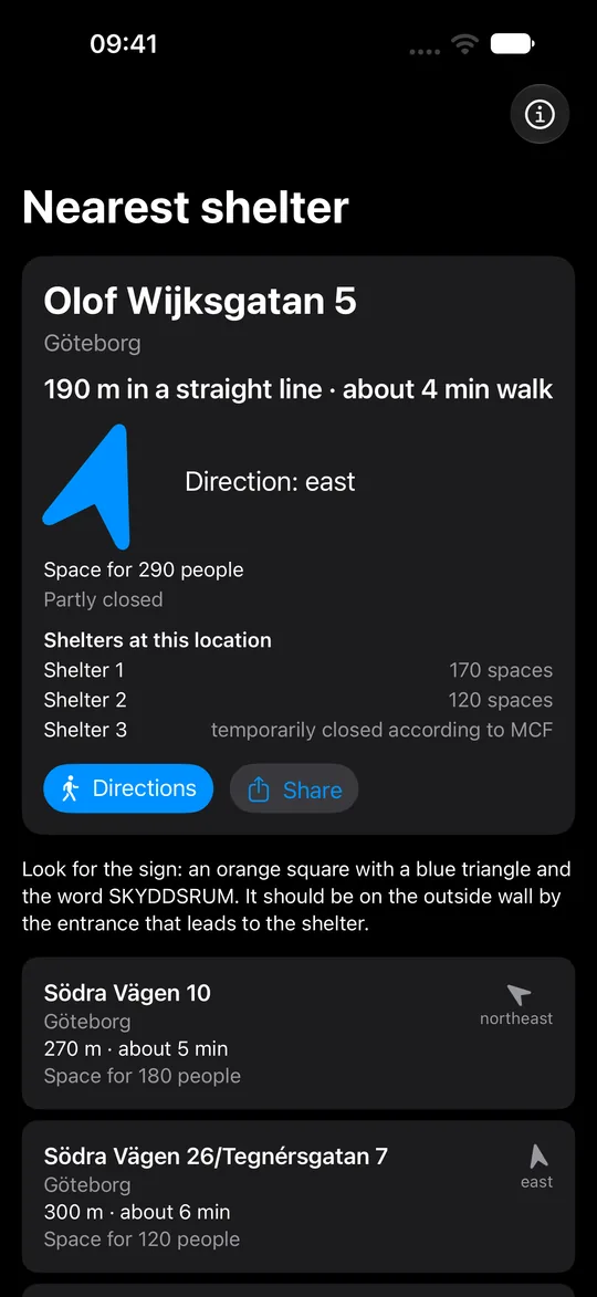
The app shows the nearest public shelters in Sweden, with distance, walking time and direction. No account, no ads.
The app has not been released yet.
Free · iPhone with iOS 16 or later · Swedish and English
The shelter data comes from the Swedish Civil Defence and Resilience Agency (MCF). The app is not from MCF.
Without an iPhone, you can find the nearest shelter on MCF’s shelter map (in Swedish).

Five shelters and their capacity
Nobody knows how full a shelter is, and Sweden’s shelters have room for about seven million people, not for everyone. So the app shows five shelters with their number of spaces, and you can move on if the first one is full.
Offline: distance and direction
The app contains more than 63,000 shelters from MCF. GPS and the compass work without mobile coverage, so the app shows the nearest shelter even when the network is down. A connection is only needed for walking directions in Apple Maps and to download the list of temporarily closed shelters.
The app downloads the latest information on temporarily closed shelters from MCF whenever your phone has a connection, and keeps it. In the app they are marked as temporarily closed according to MCF.
Other ways to take cover
If the nearest shelter is more than 1,500 metres away in a straight line, the app says how far it is and gives advice on other cover: a basement, a garage or an underground metro station.

Look for the sign at the entrance
When you are close to the shelter, the app describes the sign to look for and where it should be. Distance, arrow and directions show where the shelter itself is. The entrance may be somewhere else.

Search by town or address
If you don’t want to share your location, or you are looking on behalf of someone else, you can search by town or address.

Privacy
The app collects nothing and never sends your location anywhere. Distance and direction are worked out on your phone. It has no account, no ads and no analytics. If you tap Directions, Apple Maps opens and uses your location to work out the walking route.
This website has no cookies and no analytics, and loads nothing from other websites.
About the app
- Price
- Free, no in-app purchases.
- Phone
- iPhone with iOS 16 or later.
- Languages
- Swedish and English, following your phone’s language.
- Connection
- Only needed for walking directions and to download the list of temporarily closed shelters.
- Warnings
- The app sends none. Warnings go out as public service announcements (VMA) on radio and TV.
- Source
- The Swedish Civil Defence and Resilience Agency (MCF). The app shows the date of the data.
- Contact
- Questions and errors in the data: emil@im-safe.se
About shelters
The same advice is in the app, under About shelters. In an emergency, call 112.
During an air raid warning
The air raid warning is short blasts for one minute. Go at once to the nearest shelter or other protected place.
Basements, garages and underground metro stations also protect you. Indoors is better than outdoors, preferably a room without windows.
If you are outside with no cover: lie down, ideally in a hollow or ditch.
The All clear
When you hear the All clear, one long signal for 30 seconds, you may leave your shelter. The sirens are not always heard indoors, so listen to Sveriges Radio P4.
Listen to the signals at MCF (in Swedish)
Public Service Announcement
The Public Service Announcement (PSA) signal, 7 seconds on and 14 seconds off, is not an air raid warning. Go indoors, close windows, doors and, if possible, ventilation, and listen to Sveriges Radio P4.
Finding the shelter
You are not assigned to a particular shelter. Go to the nearest one. Anyone may use any shelter, whatever their citizenship.
The sign
Look for the sign: an orange square with a blue triangle and the word SKYDDSRUM. It should be on the outside wall by the entrance that leads to the shelter, with another by the shelter door. If you can’t find the shelter, go to the next one or to a basement, a garage or an underground metro station.
In the app, distance, arrow and directions show where the shelter itself is. The entrance may be somewhere else. When you are close, look for the sign saying SKYDDSRUM at the entrance.
If it’s full
The number of spaces is how many people the shelter was built for. Sweden’s shelters have room for about seven million people, not for everyone. If it is full, or you cannot get in, go to the next shelter or another protected place.
In the shelter
In peacetime, shelters are often used for other things and may be locked. It must be possible to make them ready within 48 hours.
During a heightened state of alert, the property owner must unlock the shelter, and people seeking shelter may need to help make it ready. The app does not know whether a shelter is ready right now.
What to bring
Expect that power, water and heating may fail, and there is no food. Bring:
- a torch
- water
- food that needs no cooking
- warm clothes
- toiletries
- medicines
- a phone charger
- a battery or wind-up radio
Bring only what you need. You may need to stay a few days.
Pets
Pets are not allowed, except guide dogs and assistance dogs. With a pet, you can take cover in a basement, a garage or a metro station.
More advice is in the brochure In case of crisis or war (Om krisen eller kriget kommer), sent to all households in 2024.